
Introduction
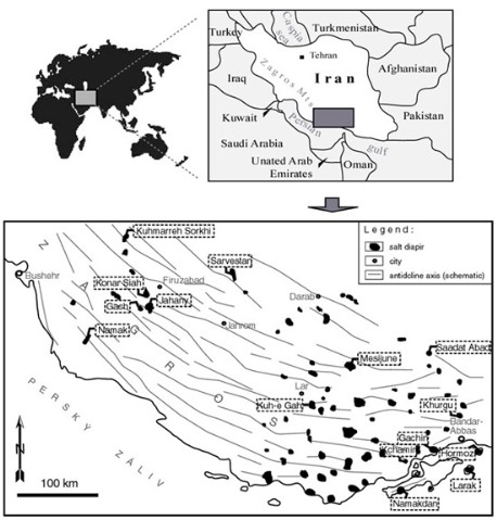
Location of the areas
The studied areas are in the eastern part of the Zagros Mountain Range and the Persian Gulf Platform. The Zagros Fold Belt is composed of elongated whaleback or box-shaped anticlinal mountains, which generally trend NW-SE. The relief is young; the principal folding started only in Middle Pliocene. South and south-western Iran (Zagros Mts.) are known for an occurrence of numerous salt mountains (diapirs – see below). Numerous salt diapirs (more than 200) are most probably the largest and the best developed halite karst areas in the world. Because of large amounts of well developed surface karts phenomena and numerous cave systems these areas offer a good opportunity for studying halite kartification in a complex scale.
History of the salt deposition
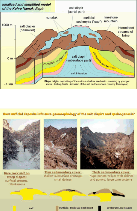
The salt, more than half a billion years old was depositing in a shalow see basin. Hundreds meters being deposited in a dry and warm climate. After next tens of billion years the salt deposits have been covered by other sedimentary rocks (limestones, sandstones) and also volcanic rocks. Therefore, the salt has been buried several kilometers under the earth surface. Due to high pressure in such depths and due to its high plasticity and density, the salt started rising towards the surface in form of cylindrical bodies of several kilometres in diameter (the diapirs). It protrudes the surrounding limestones and marls and due to an arid climate (annual mean precipitation of only 140 mm, details see below) the salt can survive on the surface and salt karst has been formed on many diapirs.
Climate
The climate in salt karst is arid. The annual average precipitation varies from 50 to 350 mm. The annual average temperature is 27 °C, in summer temperature can reach 50 °C. During our expeditions (usually January to May, temperatures varied between 15 and 40 °C on surface and between 20 and ca 30 °C in caves. The humidity on surface and in caves varied from 50 to 98 % and from 52 to 82 %, respectively. Strong precipitation events occur sporadically every several years, usually during the winter season. These sudden rains cause flash floods, which are the main danger for explorers in the cave. For the rest of the time the cave floor is either dry and covered by salt crusts, or traversed by small streams of saturated brine.
Diapir’s morphology and salt karst features
The diameter of salt diapirs usually varies between ca 1 to 15 km (along the longer axis). Rock salt belongs to the Hormoz Complex, which was deposited during Upper Precambrian (Riphean-Vendian) to Middle Cambrian times. Beds of white to greyish rocky salt and other evaporites alternate with varicoloured carbonate, siliciclastic, Fe oxides and volcano-sedimentary layers. Blocks of volcanic rocks transported by halokinesis from depth reach up to 2 km across in many diapirs.
As for various karst features, we can spot: karren, dolines, uvala-like to polje-like depressions, blind valleys, shafts, light-hole type of abysses, ponors, karst springs and caves. Presently evolving cave passages are passable from ponor to outlet in several cases. On the other hand, the older cave levels are inaccessible because they became completely filled by sediments, salt sinters and scree. Breakdown of blocks from the ceiling is common in salt caves, as can be seen comparing few years old photos with present situation in the caves.
Corrosion of the salt and a subsequent enlargement of the caves occur only in periods lasting few days after strong precipitation events, which occur sporadically every several years. These sudden rains cause flash floods, which are the main danger for explorers in the cave. For the rest of the time the cave floor is either dry and covered by salt crusts, or traversed by small streams of saturated brine.
Salt speleothems occur in a huge variety of forms. The most common speleothems are fine-grained curved stalactites, some reaching up to 4 metres length. Due to rapid and rank precipitation of salt sintres, some narrow cave passages can became temporarily inaccessible.
Figure showing location of the studied/visited diapirs.
Geologický ústav AV ČR, v. v. i.
Webmaster - Roman Pisklák
Email: sprava@gli.cas.cz